 OSU Pytheas - Data Catalog
marine environment
Type of resources
Available actions
Topics
INSPIRE themes
Keywords
Contact for the resource
Provided by
Formats
Representation types
Update frequencies
status
Scale
-
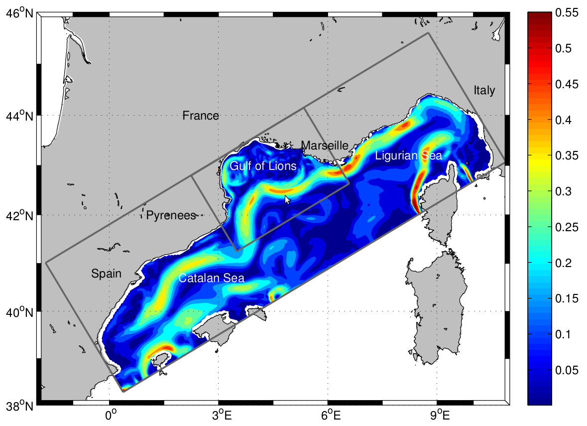
The LAgrangian Transport EXperiment (LATEX) project (2008-2011) is designed to study the mechanisms of formation of anticyclonic eddies and their influence on cross-shelf exchanges in the western part of the GoL. The dynamics of mesoscale eddies is particularly important in this part of the GoL since it represents a key region for regulating the outflow from the continental shelf. The eddy dynamics is investigated using Symphonie, a 3-dimensional, primitive equation model, with a free sea surface, hybrid sigma coordinates, based on Boussinesq and hydrostatic approximations [Marsaleix et al., 2006, 2008]. We use the upwind-type advection-diffusion scheme adapted by Hu et al. [2009] to improve the ability of the model to reproduce coastal mesoscale eddies in the western part of the GoL. In the present study, the model is implemented over the whole GoL with an horizontal resolution of 1 km × 1 km (Figure 1). The vertical discretization consists of 40-hybrid vertical levels. The vertical resolution varies from 1 m in the upper ocean to 40 m near the bottom. "For a complete review of the LATEX projet, see : - Petrenko, A., A., Doglioli, A.M., Nencioli, F., Kersalé, M., Hu, Z., d'Ovidio, F. (2017). A review of the LATEX project: mesoscale to submesoscale processes in a coastal environment. Ocean Dynam., 67:513 - doi: 10.1007/s10236-017-1040-9 - https://doi.org/10.1007/s10236-017-1040-9 ----- Le projet LAgrangian Transport EXperiment (LATEX) (2008-2011) est conçu pour étudier les mécanismes de formation des tourbillons anticycloniques et leur influence sur les échanges entre plateaux dans la partie occidentale du GdL. La dynamique des tourbillons à méso-échelle est particulièrement importante dans cette partie du GdL, car elle représente une région clé pour la régulation du flux sortant du plateau continental. La dynamique des tourbillons est étudiée à l'aide de Symphonie, un modèle d'équation primitive tridimensionnel, avec une surface de mer libre, des coordonnées sigma hybrides, basé sur Boussinesq et des approximations hydrostatiques [Marsaleix et al., 2006, 2008]. Nous utilisons le schéma d'advection-diffusion de type vent debout adapté par Hu et al [2009] pour améliorer la capacité du modèle à reproduire les tourbillons côtiers à méso-échelle dans la partie occidentale du GdL. Dans la présente étude, le modèle est mis en œuvre sur l'ensemble du GdL avec une résolution horizontale de 1 km × 1 km (Figure 1). La discrétisation verticale est constituée de 40 niveaux verticaux hybrides. La résolution verticale varie de 1 m dans la partie supérieure de l'océan à 40 m près du fond. Pour plus d'information sur le projet LATEX : - Petrenko, A., A., Doglioli, A.M., Nencioli, F., Kersalé, M., Hu, Z., d'Ovidio, F. (2017). A review of the LATEX project: mesoscale to submesoscale processes in a coastal environment. Ocean Dynam., 67:513 - doi:10.1007/s10236-017-1040-9 - https://doi.org/10.1007/s10236-017-1040-9
-
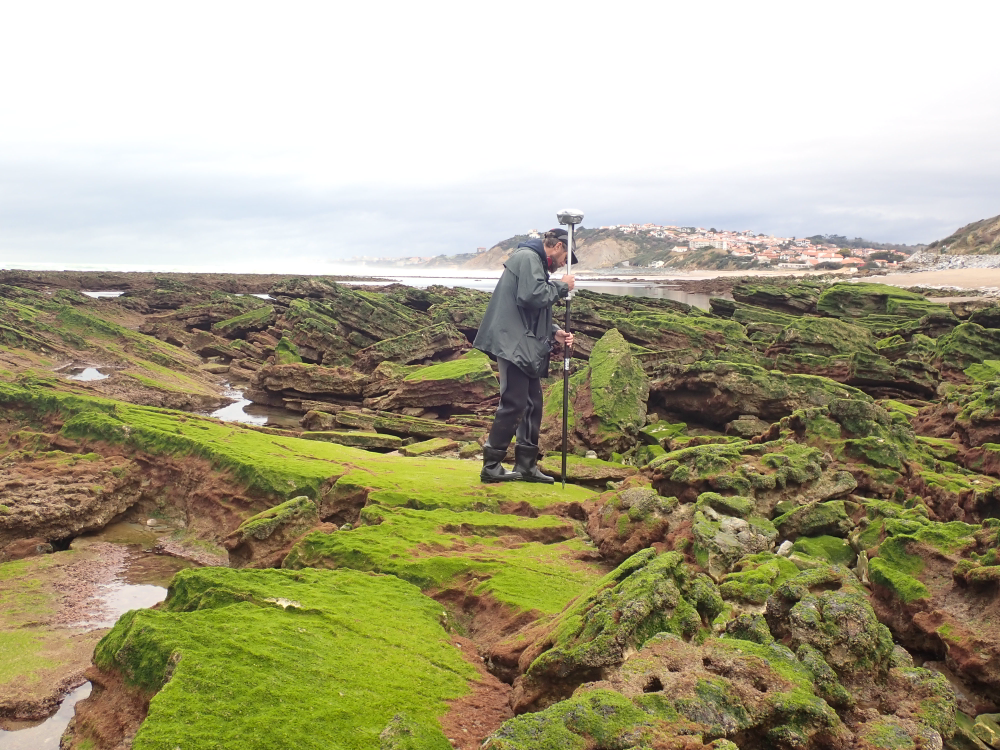
The present dataset is based on a nine site study of fine seabed topography in intertidal zones. Four coral sites (Maupiti A, B and C and Niau islands) and five rocky sites (Ars en Ré, Socoa, Parlementia A and B and Banneg island) have been explored. The data has been gathered using on-foot GNSS RTK for all sites (Trimble R8/R8S and Leica sytems) except Banneg island, where aerial Lidar data from Litto3D program has been used. The horizontal resolution varies between 3.8 and 12cm allowing to describe a wide range of spatial scales (generally over 3 spectral decades). The data has been processed to explore the statistical and spectral metrics which can be used to characterize the architectural complexity of seabeds. Owners: - Topographic survey on Ars-en-Ré : profile X, Z in meter along a transec was operated on 10-15 Jan 2021 with On-foot Trimble R8/R8S GNSS RTK by Shom, Gladys and Univ. de Montpellier - Topographic survey on Maupiti Hoe: profile X, Z in meter along a transec was operated on 5-10 July 2018 with on-foot Trimble R8/R8S GNSS RTK by GLADYS and Université de Montpellier - Topographic survey on Niau : profile X, Z in meter along a transec operated on 10 Nov. 2021 with On-foot Trimble R8/R8S GNSS RTK - by CEREGE and MIO (OSU Pytheas) - Topographic survey on Parlementia A, and B : profile X, Z in meter along a transec was operated on 22 Fev 2023 with on-foot Leica GNSS RTK by SIAME, UPPA - Topographic survey on Socoa : profile X, Z in meter along a transec was operated on 21 Fev 2023 with on-foot Leica GNSS RTK by SIAME, UPPA and Shom - Topographic survey in high resolution of Banneg island (X, Y, Z) is made by aerial lidar litto3D on spring 2012/2013 by Shom and IGN